The Secret of Success (SOS) Program is setup to help students succeed in college. More than 50 workshops on various topics are conducted each semester and more throughout the summer.
Description: Discussing how to survive a Tsunami.
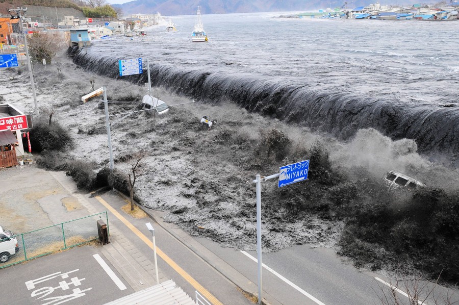
Will be showing a video (Surviving a Tsunami) of the Great Japanese Tsunami from March 11, 2011
With discussions about it’s impact and how it affected lives. How Tsunamis are formed.
Presenter: Dr. Nasir Gazdar (KCC Geology Instructor)
For 2022, World Tsunami Awareness Day is promoting Target (g) of the "Sendai Seven Campaign" which calls for Substantially increasing the availability of and access to multi-hazard early warning systems and disaster risk information and assessments to the people by 2030.
April is Tsunami Awareness Month To raise awareness on tsunami hazards and threats in the Pacific region.
“On 1 April 1946, the Aleutian Islands tsunami killed 159 people on Hawaii and five in Alaska (the lighthouse keepers at the Scotch Cap Light in the Aleutians).
The wave reached Kauai, Hawaii 4.5 hours after the quake, and Hilo, Hawaii 4.9 hours later. The residents of these islands were caught completely off-guard by the onset of the tsunami due to the inability to transmit any warnings from the destroyed posts at Scotch Cap Light on Unimak Island in Alaska.
The tsunami is known as the April Fools Day Tsunami in Hawaii because it happened on April 1 and many people thought it to be an April Fool’s Day prank.
This animation shows every recorded earthquake in sequence as they occurred from January 1, 1901, through December 31, 2020, at a rate of 1 year per second. The earthquake hypocenters first appear as flashes then remain as colored circles before shrinking with time so as not to obscure subsequent earthquakes. The size of each circle represents the earthquake’s magnitude while the color represents its depth within the earth.
This side-by-side comparison of three tsunamis generated within the same region highlights two important characteristics of tsunami behavior. First, the height of the tsunami waves (as shown by color) is strongly dependent on the size of the earthquake, namely its moment magnitude (Mw).
Tsunami warning center scientists usually measure an earthquake's "size" with the moment magnitude scale rather than the older but more famous Richter magnitude scale. The moment magnitude scale is better suited for measuring the "sizes" of very large earthquakes and its values are proportional to an earthquake's total energy release, making this measurement more useful for tsunami forecasting.
Moment magnitude numbers scale such that that energy release increases by a factor of about 32 for each whole magnitude number. For example, magnitude 6 releases about 32 times as much energy as magnitude 5, magnitude 7 about 32 times as much as magnitude 6, and so on.
Hawaii Mega Tsunami - Mauna Loa
Shorter Version
Nuuanu Slump - Mega Tsunami (1.5 Million Years Ago)
Potential Mega Tsunamis that could happen at anytime
1) Canary Islands - Cumbre Vieja Ridge, 2) Hawaii - Mauna Loa, 3) Hawaii - Kilauea - Hilina Slump 4) Norway - Aknes, B) Canada - Harrison Lake, 5) Alaska - Barry Arm fjord/Glacier
O'ahu has two Tsunami Evacuation Zones which together make up the Tsunami Hazard Area.
Standard (Red) Zone: Evacuated any time there is a Tsunami Warning
Extreme (Yellow) Zone: Only evacuated if there is a Tsunami Warning due to an earthquake originating from Eastern Aleutian Islands with a magnitude 9.0 or greater
Goals
Increase public awareness of areas at risk of experiencing direct impacts from tsunamis.
Improve public understanding of the two separate evacuation zones.
Residents and visitors in the:
Standard (Red) Evacuation Zone know to evacuate for any Tsunami Warning.
Extreme (Yellow) Evacuation Zone (170,000 more people) understand they do not always need to evacuate.
Reduce Over-evacuation which has the potential for unnecessary congestion and delays for those who truly need to evacuate.
Do you know what to do during an earthquake and tsunami?
To help keep the coastal community and its visitors safe, Tsunami Safe, an online training program, was created to educate employees in the hospitality industry—but everyone is welcome.
This training takes about 30 minutes to complete. There are two modules, and each module has 10 questions to self-test your knowledge.
- In Module 1 learn about what causes tsunamis and the different types of tsunamis.
- In Module 2 learn about how to recognize when a tsunami is coming and what to do.
After you complete both modules, you can get a certificate of completion.
Be sure to tell your friends and family that they can learn here too.
A tidal bore is a strong wave that occurs when a high tide enters a narrow bay, estuary, or river that's shallow and sloping. The wave travels upstream against the current, reversing the direction of the river's flow. Tidal bores can be dangerous to swimmers and boaters, and can advance quickly and travel long distances.